Bana Department (Bana)
Bana is a department or commune of Balé Province in southern Burkina Faso. Its capital lies at the town of Bana. According to the 1996 census the department has a population of 12,299.
Towns and villages and populations in the department are as follows:
* Bana (2 769 inhabitants) (capital)
* Bassana (918 inhabitants)
* Bissa (357 inhabitants)
* Danou (1 311 inhabitants)
* Fofina (189 inhabitants)
* Ouona (3 170 inhabitants)
* Sienkoro (485 inhabitants)
* Solonso (635 inhabitants)
Towns and villages and populations in the department are as follows:
* Bana (2 769 inhabitants) (capital)
* Bassana (918 inhabitants)
* Bissa (357 inhabitants)
* Danou (1 311 inhabitants)
* Fofina (189 inhabitants)
* Ouona (3 170 inhabitants)
* Sienkoro (485 inhabitants)
* Solonso (635 inhabitants)
Map - Bana Department (Bana)
Map


Country - Burkina_Faso
 |
 |
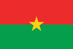
| Flag of Burkina Faso | |
The largest ethnic group in Burkina Faso is the Mossi people, who settled the area in the 11th and 13th centuries. They established powerful kingdoms such as the Ouagadougou, Tenkodogo, and Yatenga. In 1896, it was colonized by the French as part of French West Africa; in 1958, Upper Volta became a self-governing colony within the French Community. In 1960, it gained full independence with Maurice Yaméogo as president. Throughout the decades post independence, the country was subject to instability, droughts, famines and corruption. Various coups have also taken place in the country, in 1966, 1980, 1982, 1983, 1987, and twice in 2022, in January and in September, as well as an attempt in 1989 and another in 2015.
Currency / Language
| ISO | Currency | Symbol | Significant figures |
|---|---|---|---|
| XOF | West African CFA franc | Fr | 0 |
| ISO | Language |
|---|---|
| FR | French language |